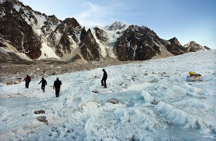
A team from Sikkim’s Science and Technology department recently embarked on a two-week scientific expedition to the East Rathong glacier and three glacial lakes in the Gyalshing district.
The purpose was to assess the risk of potential glacial lake outburst floods (GLOFs) and evaluate the current status of the glacier.
“The expedition, conducted from June 22 to July 4, is part of our ongoing study of glacier dynamics and GLOF risk assessment,” explained a department source.
As many as 19 potentially vulnerable glacial lakes have been identified, including the three studied during this expedition. This initiative follows the devastating flash flood triggered by a GLOF from the South Lhonak Lake on October 4 last year.
The study aims to inform policies and strategies to mitigate natural disaster risks. The team of scientists and researchers began their journey in Yuksom, the last car-accessible village in west Sikkim.
They then trekked for three days to reach the East Rathong glacier, situated at elevations between 4,600 and 6,700 meters near Khangchendzonga National Park. This glacier feeds the Rangit River, which eventually merges with the Teesta at Triveni in Kalimpong district.
The team split into two groups for the study. One group conducted a bathymetric survey of Tikip La Lake, Bhaley Pokhari, and Rathong Lake using an unmanned survey vehicle (USV). This hydrographic survey mapped the depths and shapes of the underwater terrain. Key findings included:
Tikip La Lake: Maximum depth of 55 metres, with no defined open outlet despite downstream water flow.
Bhaley Pokhari: Maximum depth of 42 metres, with a clear-cut outlet.
Rathong Lake: Maximum depth of 25.4 metres, with a clear-cut outlet.
The second group focused on the glacier’s velocity and vertical retreat, the glacio-hydrology of melt water streams, and conducted a Differential Global Positioning System (DGPS) survey for enhanced accuracy of the glacier’s location and surroundings. They also upgraded an automatic weather station at the glacier by adding new instruments.
“The data collected during the expedition will be analysed by experts to develop recommendations aimed at reducing natural disaster risks, particularly GLOFs,” stated an official. This comprehensive study is expected to significantly contribute to disaster risk management strategies in the region.


