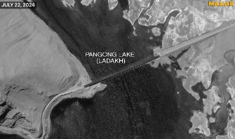
China has finished the construction of a 400-metre bridge across Pangong Tso, linking its northern and southern banks. Recent satellite images from July 22, reveal vehicles traversing this newly-constructed bridge, which enhances connectivity in the region.
The updated satellite imagery, accessed by media, shows numerous military structures on the northern side of Pangong Tso. This area has been under Chinese control since 1958 and is located close to the Line of Actual Control (LAC) in Ladakh.
Key military installations include the Khurnak Fort, situated on the northern shore of the lake. This fort, established as a Chinese stronghold in 1958, was once a disputed boundary marker between Bharat and China.
Despite this historical contention, the fort remains under Chinese control. Current images depict Khurnak Fort equipped with two helipads and a series of fortified trenches running north to south. Additionally, an existing artillery site and an open defensive position, likely to be housing a Chinese surface-to-air missile launcher, are visible.
The newly-constructed bridge has significantly reduced the travel distance between the lake’s banks by 50-100 kilometres, cutting several hours off the travel time. A parallel road facilitates the movement of troops and equipment along the lake’s bank.
In response to these developments, Bharat’s External Affairs Ministry reiterated a previous statement, “This bridge is being constructed in areas that have been under illegal occupation by China for approximately 60 years. Bharat has never accepted this illegal occupation.”
Tensions between Bharat and China along the LAC have been high since May 2020, marked by violent clashes in Eastern Ladakh. Notably, 20 Indian soldiers were killed in the Galwan Valley, situated north of Pangong Tso. China reported four fatalities, though other reports suggest the actual number was closer to 40.
Further skirmishes occurred on the northern bank of Pangong Lake, leading to the establishment of a demilitarised zone as part of a de-escalation agreement. This arrangement resulted in the removal of numerous Chinese structures between the geographical markers “Finger 4” and “Finger 8,” which delineate portions of the northern bank of Pangong Tso.


